Visit Wilderness
Search for a wilderness as the destination for your next outdoor adventure.

Why Visit Wilderness?
Learn more about the diverse ways in which we benefit from wilderness and threats wilderness areas face today.
1
Search for a wilderness as the destination for your next outdoor adventure.

While wilderness can be appreciated from afar—through online content, television, or books—nothing compares to experiencing it firsthand. Activities like camping, hiking, or hunting allow you to fully enjoy the recreational, ecological, spiritual, and health benefits that wilderness areas offer. These areas provide “outstanding opportunities for solitude or a primitive and unconfined type of recreation,” chances to observe wildlife, moments to renew and refresh, and the physical benefits of outdoor exercise. In many wilderness areas, you can even bring your well-behaved dog.
Learn more about the diverse ways in which we benefit from wilderness and threats wilderness areas face today.
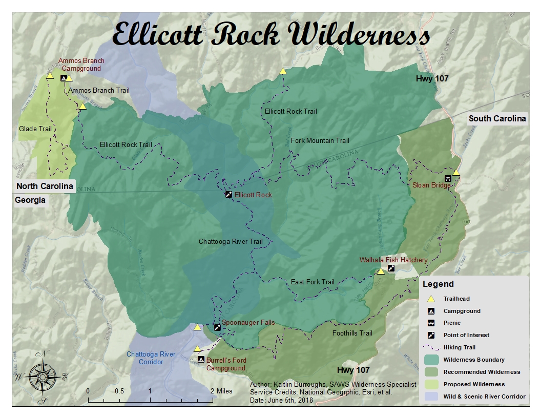
Ellicott Rock Wilderness sits at the southern tip of the romantically hazy Blue Ridge Mountains. Congress designated Ellicott Rock Wilderness in 1975, later expanding it in 1986. The wilderness uniquely spans three states in Sumter, Nantahala, and Chattahoochee National Forests of South Carolina, North Carolina, and Georgia respectively. It is named after Major Andrew Ellicott who was tasked with the arduous job of locating the 35th parallel to settle a border dispute. On December 26th, 1811, Major Ellicott inscribed the letters "N-G" on a rock along the Chattooga River bank declaring the Georgia-North Carolina border.
Ellicott Rock Wilderness has a temperate climate with an average rainfall of 80 inches per year creating a dense forest with steep, rugged terrain. The landscape is largely covered in a variety of hardwoods, white pines, and hemlocks with bountiful water sources weaving throughout. The untamed Chattooga Wild and Scenic River runs through the heart of the wilderness and is one of the longest and largest free-flowing mountain rivers in the southeast. The wilderness provides visitors with bountiful opportunities to experience solitude and see an impressive array of plant and animal communities while hiking, camping, hunting, fishing, swimming, or kayaking.
Ellicott Rock Wilderness maintains 18 miles of hiking trails with trailheads in both South Carolina and North Carolina. In South Carolina, the highly trafficked Chattooga River Trail (4 miles) and East Fork Trail (2.5 miles) join together and lead you down to Ellicott's Rock itself. For a quieter and longer traverse to Ellicott Rock, you can hike along the winding Fork Mountain Trail (6 miles) that shares a junction with the Ellicott Rock Trail of North Carolina. To find the best opportunities for solitude, access Ellicott Rock by hiking along the Ellicott Rock Trail (7 miles) in North Carolina. The trail has two trailheads along Bull Pen Road and crosses the Chattooga Wild and Scenic River in the middle. Be aware, Ellicott Rock is not visibly marked and can be difficult and dangerous to find. Kayaking the Chattooga Wild and Scenic River is also a scenic, secluded, and adventurous way to experience Ellicott Rock Wilderness. Paddlers may access the river at designated locations, during the boating season (December-April), and when water levels reach 350 cfs or greater.
Plan ahead and prepare for your adventure in Ellicott Rock Wilderness and don't forget to Leave No Trace.
How to follow the seven standard Leave No Trace principles differs in different parts of the country (desert vs. Rocky Mountains). Click on any of the principles listed below to learn more about how they apply in the Ellicott Rock Wilderness.
For more information on Leave No Trace, Visit the Leave No Trace, Inc. website.
Digital and paper maps are critical tools for wilderness visitors. Online maps can help you plan and prepare for your visit ahead of time. You can also carry digital maps with you on your GPS unit or other handheld GPS device. Having a paper map with you in the backcountry, as well as solid orienteering skills, however, ensures that you can still route-find in the event that your electronic device fails.
Motorized equipment and equipment used for mechanical transport is generally prohibited in all wilderness areas. This includes the use of motor vehicles, motorboats, motorized equipment, bicycles, hang gliders, wagons, carts, portage wheels, and the landing of aircraft including helicopters.
Date: January 3, 1975
Acreage: 3,600 acres
(Known as the Eastern Wilderness Areas Act) - Public law 93-622 (1/3/1975) To further the purposes of the Wilderness Act by designating certain acquired lands for inclusion in the National Wilderness Preservation System, to provide for study of certain additional lands for such inclusion, and for other purposes
For more information (To download or see all affected wilderness areas) visit our law library for 93-622 or special provisions for 93-622 or legislative history for 93-622 for this law.
Date: June 19, 1984
Acreage: 3,680 acres
North Carolina Wilderness Act of 1984 - Public law 98-324 (6/19/1984) To designate certain public lands in North Carolina as additions to the National Wilderness Preservation System
For more information (To download or see all affected wilderness areas) visit our law library for 98-324 or legislative history for 98-324 for this law.
Date: October 19, 1984
Acreage: 2,000 acres
Georgia Wilderness Act of 1984 - Public law 98-514 (10/19/1984) To designate certain National Forest System Lands in the State of Georgia as Wilderness, and for other purposes.
For more information (To download or see all affected wilderness areas) visit our law library for 98-514 or legislative history for 98-514 for this law.
People who volunteer their time to steward our wilderness areas are an essential part of wilderness management. Contact the following groups to inquire about volunteer opportunities. Groups are listed alphabetically by the state(s) in which the wilderness is located.